Winter Storm Expected to Impact our Area on Wednesday
The National Weather Service has issued a Winter Weather Advisory for Southern Connecticut and Winter Storm Warnings for Litchfield, Hartford, Tolland and Windham counties beginning this evening and continuing until mid-afternoon on Wednesday.
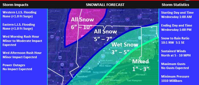
The following forecast is based on a blend of the GFS and NAM models:
Today: Very light snow today in the Northwest Hills with little or no accumulation and no significant impact on the afternoon rush hour. Highs near 30 F.
Tonight: The light snow is forecast to become steady after midnight and is forecast to become moderate by daybreak with lows in the upper 20's. Only a minor impact on overnight travel is expected with a thin snow cover on some roads.
Wednesday Morning: Moderate snow is expected with maximum snowfall rates up to ¾” per hour during the morning rush hour. Temperatures are forecast to rise into the low 30's. The impact on the morning rush hour is currently forecast to be minor to moderate with a light snow cover on most roads and moderate snow falling. Since the temperatures will be near 32 F, the snow should melt relatively quickly on any treated roads, especially the highways. The snow may mix with sleet and rain at times in southeastern CT.
The Department of Emergency Services and Public Protection Division of Emergency Management and Homeland Security will continue to closely monitor this storm.