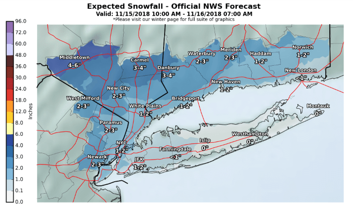
The National Weather Service has issued a Winter Weather Advisory for Southern Connecticut, the Lower Hudson Valley and portions of Northeast New Jersey from Thursday afternoon into Thursday night.Accumulating snow, sleet and freezing rain across southern Connecticut, the Lower Hudson Valley and most of northeast New Jersey from Thursday possible from midday Thursday through Thursday night (Friday morning Orange and Putnam County). A period of snow and sleet changing to rain in the afternoon for New York City, Long Island and Hudson County.Snow/Ice/Sleet
- There is a high potential for an accumulation of 1 to 5 inches of snow and sleet and up to one quarter of an inch ice across the Advisory area and a moderate potential for up to a slushy inch or two of snow and sleet across New York City, Long Island and Hudson County.
- Snow and sleet will change to rain during the afternoon across New York City and Long Island.
- The transition to rain will go into the night time hours across the Advisory Area.
- Travel will become hazardous due to poor visibility and snow and ice covered roads over the Advisory area. Some slick spots are also possible Thursday afternoon in New York City and on Long Island.
Wind
- Wind gusts up to 40 to 45 mph are possible across Long Island, southern New York City and coastal Connecticut late Thursday night.
- This may down a few tree limbs and powerlines.
- There is still uncertainty as to the strength, location and timing of any stronger wind gusts with this storm. Confidence in this wind gust forecast is low to moderate. Winds are more likely to be lower than this forecast than higher.
Learn more on NWS website here
R