The National Weather Services has issued a Winter Weather Advisory, in effect until 1:00 am on Tuesday, February 16.
Light to moderate freezing rain is expected tonight into Tuesday morning as an area of low-pressure approaches and moves over the region.
Below is this week's weather outlook, courtesy of NWS. It looks like snow accumulation is headed to our area on Thursday.
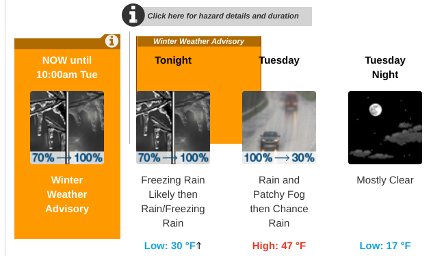
Tonight
Freezing rain likely before 1am, then rain. Temperature falling to near 30 by 9pm, then rising to around 36 during the remainder of the night. East wind 5 to 9 mph. Chance of precipitation is 100%. Total nighttime ice accumulation of around a 0.1 of an inch possible.
Tuesday
Rain, mainly before 10am. Patchy fog before 10am. High near 47. East wind 5 to 8 mph becoming west in the afternoon. Chance of precipitation is 100%. New precipitation amounts between a quarter and half of an inch possible.
Tuesday night
Mostly clear, with a low around 17. Wind chill values between 5 and 10. Northwest wind 10 to 13 mph.
Wednesday
Sunny, with a high near 30. Wind chill values between 5 and 15. Northwest wind 7 to 10 mph.
Wednesday night
A 20 percent chance of snow after 4am. Increasing clouds, with a low around 17. North wind around 6 mph.
Thursday
Snow, mainly after 7am. High near 27. Chance of precipitation is 90%. New snow accumulation of 2 to 4 inches possible.
Thursday night
Snow before midnight, then snow and sleet. Low around 27. Chance of precipitation is 90%.
Friday
A chance of snow, mixing with rain after 10am, then gradually ending. Partly sunny, with a high near 36. Chance of precipitation is 40%.
Friday night
Partly cloudy, with a low around 21.
Learn more on NWS website here.
D