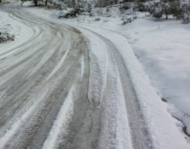
The National Weather Service is predicting snow mixed with ice to begin tomorrow, Wednesday, February 7
✓ Snow will likely accumulate across the watch area through the morning and early afternoon. Expect travel delays for both the Wednesday morning and Wednesday evening commute.
✓ Precipitation will transition to a wintry mix then to freezing rain Wednesday morning into the afternoon.
✓ A slight change in the track of the storm will impact precipitation types, and snowfall and ice accumulation amounts.
Wednesday
Snow, freezing rain, and sleet before 1pm, then rain, snow, and sleet between 1pm and 2pm, then rain after 2pm. High near 37. Wind chill values between 10 and 20. East wind 6 to 8 mph. Chance of precipitation is 100%. Little or no ice accumulation expected. New snow and sleet accumulation of 1 to 3 inches possible.
Wednesday Night
Rain and sleet likely before 9pm, then a chance of snow and freezing rain between 9pm and midnight. Cloudy, then gradually becoming partly cloudy, with a low around 23. Wind chill values between 15 and 20. Southwest wind 7 to 10 mph becoming northwest after midnight. Winds could gust as high as 20 mph. Chance of precipitation is 70%. Little or no ice accumulation expected. New snow and sleet accumulation of less than a half inch possible.
For additional weather details, visit NWS here.
N