NOAA has forecasted strong to severe thunderstorms ahead of an approaching cold front today into this evening as well as a susceptible area where there will be a higher chance of flash flooding.
- Slight Risk of Severe Thunderstorms today into this evening, particularly for Northeastern New Jersey, Lower Hudson Valley, much of Southern Connecticut, New York City Metro and Western Long Island.
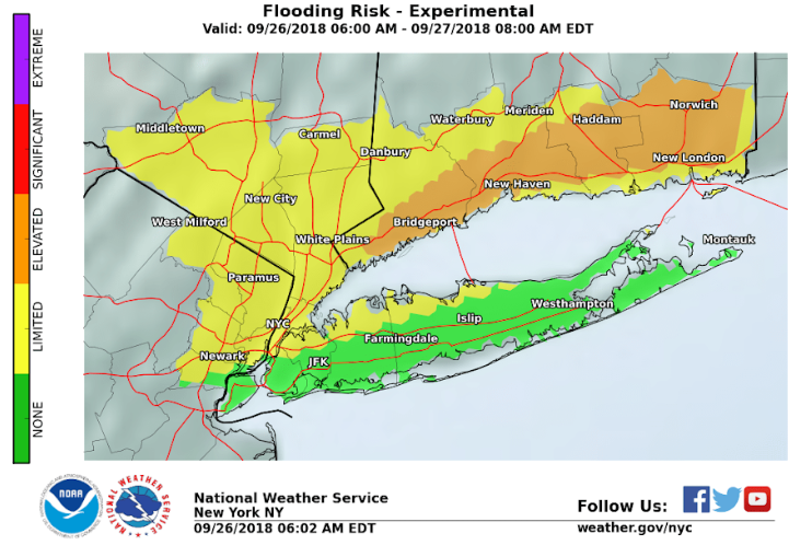
- Low chances of flash flooding for mainly Southern Connecticut with showers and thunderstorms today into tonight. This is where a widespread 4 to 6 inch rain with isolated 8 inch amounts fell yesterday, with saturated grounds and thereby making this area quite vulnerable for flash flooding.
Potential Hazards and Impacts:
Localized Flash Flooding Threat Today into this Evening:
- Despite basin average rainfall of 1/4 to 1/3 inch forecast through this evening with locally higher amounts, a minor urban and poor drainage flooding threat exists, with a limited flash flooding threat due to the recent very heavy rainfall.
- Strong to damaging wind gusts are possible with this activity, which could down some tree limbs, trees and powerlines and/or cause structural damage. Isolated to scattered power outages are possible. There is an isolated tornado threat as well northwest of NYC.
Confidence or Forecast Scenarios:
- There is uncertainty on how organized or widespread thunderstorms will be ahead of the cold front.
- There is moderate to high confidence in a organized line of thunderstorms approaching the region in the evening along a cold front, but uncertainty on how quickly it will weaken as it enters the Tri-State region and moves towards the coast.
- The primary threat for strong to damaging winds gusts across Northeastern New Jersey, the Lower Hudson Valley, Southwestern Connecticut, New York City metro, and Western Long Island. The severe threat will diminish as the line approaches the coast.
Learn more HERE.
R