Wintry Mix of Snow, Sleet and Freezing Rain Expected to Begin Tonight

There is a Winter Weather Advisory for Southern Connecticut and southeast New York
The National Weather Services has issued the following winter weather warnings and advisories:
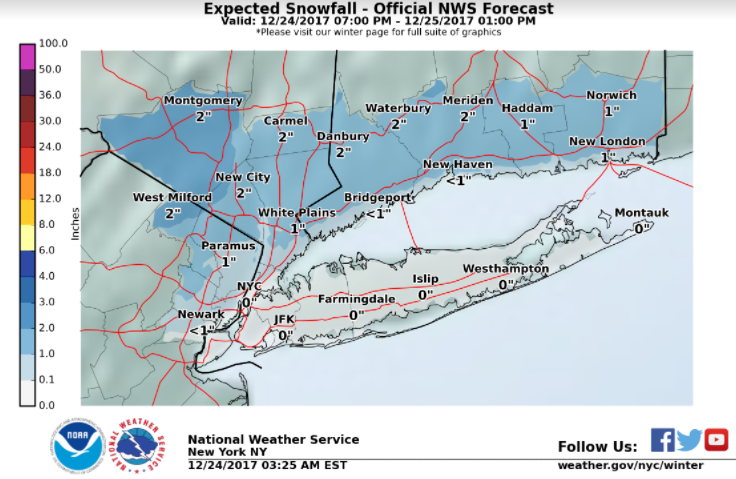
Late Christmas Eve through Christmas morning- Wintry Weather
- A quick moving low pressure system is expected to bring a mix of snow, freezing rain and ice to interior portions of northeastern New Jersey, the Lower Hudson Valley, and southern Connecticut. An inch to two of snow and a few hundredths of ice can be expected. A winter weather advisory is in effect.
- For the NYC metro and Long Island, mainly rain is expected.
- Precipitation tapers off Monday morning.
See the full Probabilistic Snowfall Forecast information at: https://www.weather.gov/okx/winterChristmas Day - Strong Winds
- West/Northwest winds 25 to 35 mph with gusts of 40 to 50 mph likely Monday morning through afternoon. Winds slowly subside Monday night.
- Strong winds may blow down tree limbs and power lines, cause scattered power outages, and damage Christmas decorations.
Mid to Late week - Deep Freeze
- High temperatures Wednesday through Friday will remain below freezing, with overnight lows in the teens and single digits. These conditions may continue into early next week.
- The prolonged cold weather would increase potential for frozen/burst pipes, space heating related mishaps, and other cold weather impacts.
Stay tuned to your latest NWS forecasts: http://www.weather.gov/okx
R