Moderate to Heavy Snow for Friday Morning Commute
The National Weather Service (NWS) reports that a quick-moving but the intensifying low-pressure system is expected to bring a period of moderate to heavy snow for the Friday morning commute.
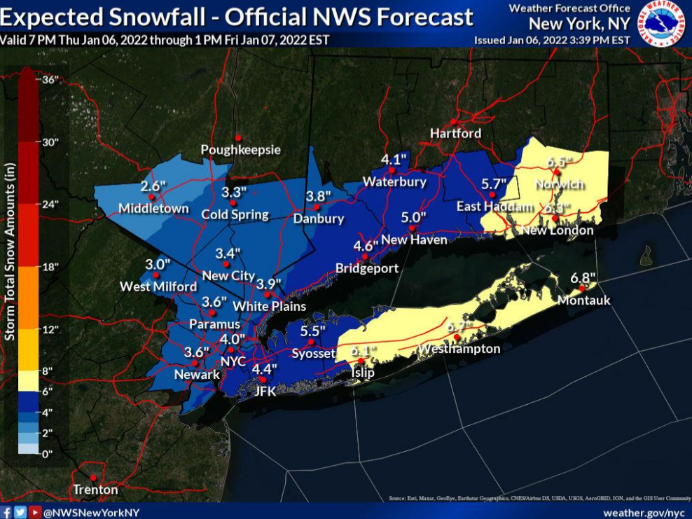
NWS Predicts Total Snowfall Tonight into Friday morning
5 to 7” for E LI and SE CT.
3 to 5” for NYC/NJ metro, W LI, SW CT, and S Westchester.
2 to 4” for Interior portions of Lower Hudson Valley and NE NJ.
Snowfall Rates late tonight into early Friday morning
1 to 2”/hr possible across E LI and SE CT between 4am and 10am.
Up to 1”/hr possible for NYC/NJ metro, W LI, SW CT and S Westchester between 4 and 8 am. Lower rates for areas to the NW.
Likely Onset Timing: Midnight to 2 am Tonight from west to east.
Likely End Timing: Mid to Late Friday morning from west to east.
NWS ALERTS
Winter Storm Warning: Suffolk County, Middlesex and New London Counties from Midnight to noon.
Wind Weather Advisory: Remainder of local Tri-State.
FORECAST CHALLENGES
How far west heavy snow banding (1”+/hr snowfall rates) develops. The highest likelihood and duration are expected across LI and S CT.
Locally icy road conditions (black ice under snow cover) possible for NYC and the coast with temps around freezing at onset tonight, and then falling well below freezing by rush hour.
Read the complete briefing and view weather maps here.