
Ridgefield Weather:
Although the remnants of Ian will not directly impact the area, a strong frontal system invigorated by Ian will lift into the northern Mid-Atlantic states tonight and stall to the south of the region through early next week as strong high Canadian pressure builds south into New England.
This setup is increasing the potential for a period of moderate to heavy rainfall, gusty winds, and minor to locally moderate coastal impacts this weekend into Monday.
Please visit our tropical webpage for the official National Hurricane Center forecast on Ian.
Hazards and Impacts:
Winds -
- Potential is increasing for gusty winds (20 to 25 mph sustained w/ 30-45 mph peak gusts) late Saturday night into Sunday night for coastal areas, including NYC. Highest winds will be across southern and eastern Long Island.
- Weaker winds are expected for interior areas.
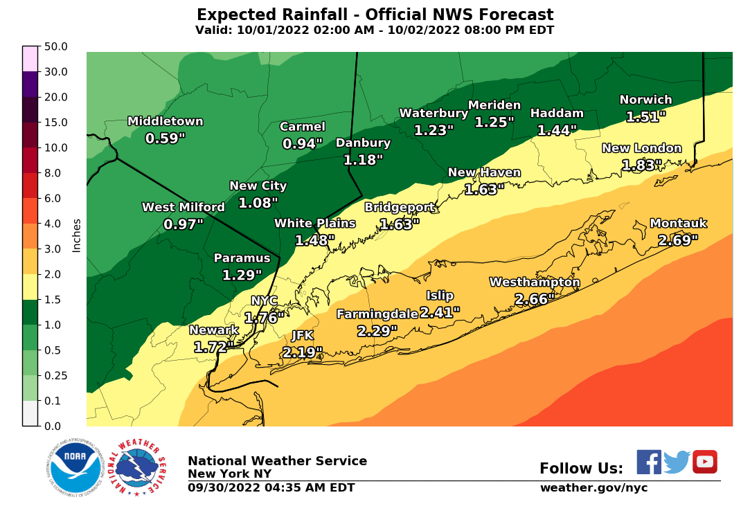
Rainfall -
- 1 to 3 inches of rainfall is likely late tonight into Saturday evening across NE NJ, NYC and Long Island, highest amounts to the south and east. Reasonable worst-case scenario of 3" to isolated locally 5" of rainfall during this time. Minor urban and poor drainage flooding is the primary threat, with a localized threat for flash flooding.
- Lesser rainfall amounts and potential impacts for interior areas.
Coastal Flooding
- Isolated minor coastal flooding is possible Saturday afternoon along the southern bays of Nassau County, and possibly Jamaica Bay.
- Widespread minor coastal flooding is likely for the Sunday and Monday afternoon high tides for vulnerable NY/NJ Harbor, western Long Island Sound, and western Great South Bay communities. Localized moderate coastal flooding possible along the southern bays of Nassau County and possibly Jamaica Bay.
- Minor coastal flood impacts are possible along eastern great South Bay and Peconic and Gardiners Bay communities during this time.
Ocean Beachfront Impacts
- Areas of beach flooding and dune base erosion around times of high tide Sunday and Monday. Localized washovers possible in the most vulnerable locations.
- Dangerous longshore/rip currents
Marine
- Gale conditions are likely, with 8 to 12 seas, on the ocean waters Sunday through Sunday night. Gale conditions are possible on the remainder of the nearshore harbor, bay and sound waters.
R