Connecticut Emergency Operations Center has been activated as a major winter storm continues impacting our areaCurrent storm highlights from The Department of Emergency Services and Public Protection Division of Emergency Management and Homeland Security:
- At 11:00 AM radar showed heavy snow falling across most of the state. North and Northeast winds are currently sustained at 25MPH with gusts to 35 – 45 MPH at times.
- Eversource and UI are reporting a total of 450 customers without power across the state.
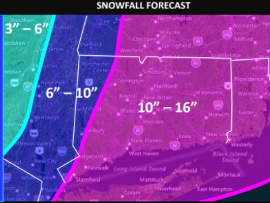
- Total snowfall currently ranges between 6 – 10 inches across the state.
The following forecast is based on a blend of the GFS, HRRR and NAM models which are in good agreement:This afternoon:Heavy snow at times with snowfall rates between 1” – 3” per hour until 3:00 PM. The snow intensity is expected to slowly taper down to moderate snow by 4:00 PM and to light snow by 6:00 PM. However some bands of heavier snow could persist into this evening in a few towns. Strong winds gusting to 45 - 55 MPH at times will cause blowing and drifting of the snow and also reduce visibility to near zero at times. The strong winds may also cause some additional power outages. A major impact is possible for the afternoon rush hour with 2 – 4 inches of snow on most roads and moderate snow falling.This evening and overnight:The snow is forecast to end from west to east between 6:00 – 9:00 PM with considerable blowing and drifting of snow continuing overnight. Bitterly cold conditions are expected with lows between 0 F and 10 above and winds gusting to 30 - 40 MPH at times causing wind chills to drop to -20 F at times.Friday and Saturday:Bitterly cold and windy with highs around 10 F and overnight lows between 0 and -10 F. Wind chills are forecast to range from around -10 F during the days down to -20 to -30 F at night.
The Department of Emergency Services and Public Protection Division of Emergency Management and Homeland Security will continue to closely monitor this storm.
W