Bundle Up on Thanksgiving!
An arctic front will pass through the region Wednesday evening, bringing gusty winds and the coldest airmass of the season for Wednesday night into Thanksgiving Day.
Potential Hazards and Impacts:
Gusty Winds across the Tri-State Wednesday Afternoon through Thursday Afternoon
- West to Northwest winds of 15 to 20 mph and gusts of 25 to 35 mph are likely across the region Wednesday Afternoon into Thursday Afternoon.
- A few gusts to 40-45 mph are possible briefly in the wake of an arctic frontal passage late Wednesday into Wednesday evening, between 5pm and 9pm.
- This may down a few tree limbs and powerlines and/or cause structural damage.
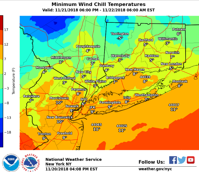
Cold Temperatures across the Tri-State Wednesday Night through Thursday Night areawide:
- Temperatures will drop from the upper 20s to lower 30s Wed Evening to the teens to around 20 degrees by Thanksgiving morning.
- Windchills will bottom out in the single digits late Wednesday Night into early Thursday Morning.
- Highs on Thanksgiving Day will only top out in the lower to mid 20s, with windchills in the teens.
- Temperatures Thursday Night will drop into the single digits across the interior and pine barrens of Long Island, with lower to mid teens for the city and coast. Windchills will be similar to air temperatures.
- Below is a graphic of minimum Windchill Temperatures expected for early Thanksgiving morning.
A Few Snow Showers expected across the Tri-State Late Wednesday into Wednesday Evening:
- A few snow showers are expected to accompany an arctic frontal passage late Wednesday Afternoon Into Wednesday Evening.
- There is potential for an isolated snow squall with brief heavy snow, gusty winds, poor visibility, and falling temperatures.
- Any location that sees a snow squall will have the potential to see a quick dusting to inch of snow and travel conditions becoming rapidly hazardous.
- Uncertainty/Forecast Scenarios: At this time there is low predictability on how widespread the snow shower activity will be, and if any heavier snow squalls will develop. The low threat for a snow shower exists for the entire Tri-State region, with highest probability to the North and Northwest of NYC.
NWS New York Website: https://www.weather.gov/okx/
W