
High heat and humidity continue into early next week
A Bermuda high will remain offshore through early in the week, continuing to provide very warm, humid conditions in our area.
A heat advisory is now in effect through 8 pm Monday.
There remains a localized threat of flash flooding with any storms, especially north and west of NYC for Sunday afternoon and early Sunday evening.
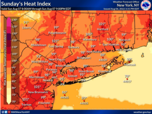
Heat – Maximum heat index values will range mainly from 95 to 100 degrees on Sunday afternoon and lower and middle 90s across eastern coastal sections.
Values will then increase slightly into the upper 90s to lower 100s on Monday afternoon in most places, with mainly middle 90s (and a few upper 90s) across eastern coastal sections.
These conditions could potentially linger into Tuesday until a cold front breaks the heat mid-week.
Flash Flood Risk – Scattered showers and thunderstorms this evening may result in localized flash flooding, mainly north and west of NYC. The localized risk of flash flooding continues on Sunday as additional scattered showers and thunderstorms are possible in the afternoon and early evening.
Visit NWS online HERE for weather updates.